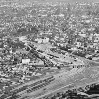
The Setting
The Packing Houses
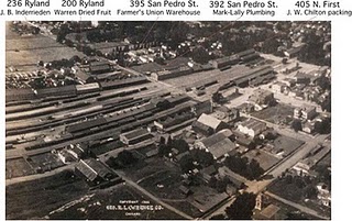
The specific warehouses I want to model are those on the left side of the tracks just before North First Street. Checking out these warehouses on Sanborn maps shows the occupants of the warehouses changing with each year, but some of the names are quite familiar.Here's a list from east to west from First Street, past the Ryland Park swimming pool, and past N. San Pedro St. along Ryland St. That's roughly from opposite the old passenger station to opposite the SP freight station:
According to the 1915 Sanborn map, the buildings were occupied by:
- J . W. Chilton and Company dried fruit packing. (383 North First Street, later renumbered to 405 N. First St.) Mentioned in 1922 history of Santa Clara County industry. Chilton was local; San Jose's Preservation Action Council's newsletter mentions that his house was at 1050 Bird Ave. in Willow Glen, and was designed by Andrew Hill.
- Mark-Lally & Co Plumbing supplies. (392 N. San Pedro St.) Plumbing and heating supply company out of San Francisco.
- Farmers Union General Warehouse. (395 N. San Pedro St.)
- Warren Dried Fruit Co. (200 Ryland St.) My grandmother supposedly worked for them in Hayward in the 1930's.
- J. B. Inderrieden & Co Dried Fruit Packing (236 Ryland St.) They're not locals-they're from Chicago.
The H.L. Losse packing house at 392 San Pedro St. (the roof with the messiest writing) will eventually be the site of the Mark-Lally plumbing warehouse in 1915. The photo of that building doesn’t match the 1915 Sanborn map, primarily because Losse’s building burned down in 1911 (according to the Santa Clara County Biography Project) and he moved his company to Santa Clara. Note that the packing houses aren’t the typical slapped-together structures, but are often multi-story and huge The three story Rosenberg Brothers packing house also is another example of how packing houses aren't always low to the ground and temporary.
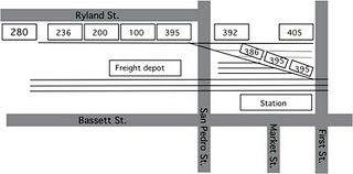
• C.I. Dick Dried Fruit Packing. (405 N. First St., same building as the Chilton warehouse)
• "Shelling Plant and Warehouse”. (395 N. First St., on the site of former yard tracks, and closer to the SP station.
• "Fruit Packing" (386 N. San Pedro St.)
• "Fruit Packing and Warehouse" (392 N. San Pedro St.), the former Mark-Lally plumbing building.
• Beer warehouse. (395-399 San Pedro St.) Shares Warren Dried Fruit Co’s warehouse.
• Warren Dried Fruit Co. (100-200 Ryland St.) They're doing pretty good to be in the same place 35 years.
• Abinante and Nola Packing Co. (236 Ryland St.) They occupied the Inderrieden warehouse. It's interesting to find them on this side of town, as their former plant on San Carlos St. is on my Vasona branch layout.
• Western Metal and Export. (280 Ryland St.) Tin salvage plant.
The three new warehouses (“Shelling Plant and Warehouse”, “Fruit Packing”, “Fruit Packing and Warehouse”) were built on land formerly part of the yard. These were one story buildings according to the 1950 Sanborn map.
1970-era SPINS maps marking locations of industries on the SP shows all these warehouses were vacant by 1972, assuming the buildings were even still there.
There were more businesses on the other side of the street close to downtown, but that's a project for a different time and a different layout. There’s an awful lot of industry for such a small area around the Market Street station, and quite enough for any self-respecting model railroad.
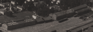
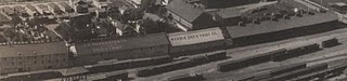
Photos of the Packing Houses
There's not a lot of close-up's of that neighborhood, but I found some photos when diving through books. As usual, I took maps of the area (this time photocopies of the Sanborn maps of the neighborhood rather than hand-drawn) and went searching through my books for potential photos showing the warehouses. As I found photos, I'd mark the location of the photo source on the map for later reference. The aerial photo leading this blog entry gives dates from 1940 and shows the row of warehouses on the left (north) side of the tracks. They're the long warehouses standing alone with the little clerestory peaks to get light into the buildings.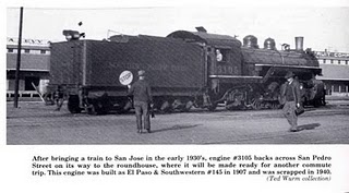
Designing the Packing House Building
So with these photos, the contents of the Sanborn maps, and a bit of guessing, here's my assumptions about what these warehouses look like, and what my model should look like. (See the table here for an even more exhaustive run-down.)Generally, what I've seen in the photo are tall (16-20' high) one to three story warehouses with sloping roofs, covered loading docks, and occasional large freight doors; the Sanborn maps confirm this, with exact wall heights, notes about boilers and motors for power, and addresses. One exception was the Inderrieden / Abinate and Nola warehouse which had 24 foot high walls and was marked as having two floors. None of the Sanborn maps show locations of doors, but all show how the buildings were divided up, and where the non-railroad loading and unloading docks must have been.
From comparing building sizes to the widths of the roadways, the warehouses appeared to be on the order of 150 feet long and 50 feet wide. The photo of locomotive 3105 shows that the loading dock to the right was sheathed below the dock, and the one to the left was not. The Sanborn maps don't give much more detail - 18' high walls, truss roofs with wood posts, covered platforms, occasional motors for running machinery, fuel oil.
Most appeared to be wooden structures, though some had corrugated iron walls. Shingle roofs were a bit more common in 1915, but most roofs were composition (tar) or metal by 1950. I’m guessing they're mostly board-and-batten structures from textures on some of the photos, and that they should appear a bit worn both from age and from lack of maintenance due to intermittent use. They'll be simple to build except for those clerestory roofs. Because my warehouses will be up against the backdrop and at an angle, getting all the rooflines correct will be a chore.